Introduction to Stretched-Grid Downscaling for S2S
It is the operationally stretched-grid downscaling Sub-seasonal to Seasonal prediction (S2S) output for different regions of interest, including Southeast China, the Pan-Tibetan Plateau, Nepal, and the Arctic shipping routes. This output is based on the modified version of the Unified Forecasting System (UFS) modeling system named FGOALS-UFS. The boundary forcing of the stretched-grid downscaling system is from the FGOALS-f2 model, which is a global uniform 1-degree fully coupled climate system model. FGOALS-UFS and FGOALS-f2 use advanced technology to enhance accuracy and effectiveness, including a state-of-the-art scale-aware Convection Resolving Precipitation scheme (RCP) and finite-volume dynamic core on a cube-sphere grid with a stretched-grid downscaling capability.
As illustrated in Figure 1, the stretched-grid downscaling original cubed sphere grid is smoothly deformed by refining the domain area of interest while creating a relatively coarse region on the opposite side of the Earth, allowing a high-resolution region within the global domain. The central stretched-grid domain has a horizontal resolution of 12.5 km and covers a region of 1200 km x 1200 km. This technique overcomes to some extent the computation limitation of producing global high-resolution modeling by providing high-resolution regions within the global domain and providing the self-consistent interactions between global and regional scales of motion and their associated phenomena as in the uniform grid global model. It’s a promising means to model regional to local climate mainly over complex terrains like Central Himalayas and the Tibetan Plateau. In Figure 2, we demonstrate a global downscaling approach that we have named "Xapp" for short. This approach utilizes the FGOALS-f2 global uniform model to drive the Xapp, while the variable grid model is used to gradually scale down the blue focus area and gain higher resolutions.
Stretched-Grid downscaling output from the FGOALS-UFS is presented on this website as a quantitative forecast of total weekly accumulated precipitation for various domains of interest, as mentioned above. Every day, there are 16 ensemble members to forecast weather patterns for the next 60 days on the S2S scale. It is updated daily based on the model initialized on the previous day at the highest resolution of ~12.5 km spatial resolution.
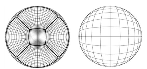
Fig1. The schematic diagram for the stretched grid.
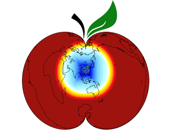
Fig2. The schematic diagram is provided to illustrate the “little red apple” downscaling configuration.